
Skiing in the Black Forest: 10 ski areas from Feldberg to the High Road
Where to spend a full day on skis, where to squeeze in a few runs, and when to go. Compare ten Black Forest ski areas with maps, elevations, rental pickup, parking, webcams and mountain forecasts.
Check snow conditions ↓Choose a ski area ↓
The Black Forest in snow, with the Vosges on the horizon. Photograph by Richardfabi · public domain.
Snow conditions at a glance
Measured snow depth and air temperature at five weather stations. Snow cover on the pistes can differ. All times are local.
| Station | Snow depth | Air temperature |
|---|---|---|
| Feldberg summit | 19 cm | -1.6 °CGusts 18 km/h |
| Seebach near Ruhestein | 0 cm | 0.2 °C |
| Bernau-Goldbach | 0 cm | — |
| Freudenstadt-Kniebis | 0 cm | — |
| Freudenstadt | 0 cm | 1.4 °CGusts 14 km/h |
The latest update is unavailable. Check the observation date shown.
You can spend a day working your way from Seebuck toward Fahl on Feldberg. At Seibelseckle, a single floodlit slope is enough for a few good runs after work. Choosing between them starts with how much skiing you want to do and how much of the day you want to spend hiring gear and changing lifts.
Looking for snow for a walk or sledding trip? See where snow has been measured and check the local webcams.
When to go. For a trip built around skiing, January and February are our first choice. Feldberg’s historical figures show a deeper average base in both months than in December. Keep Christmas and March plans flexible. For the lower High Road lifts, a recent cold spell matters more than the month on the calendar. Feldberg snowfall history.
The map marks a practical starting point for each area. Each entry links to a camera, a mountain forecast, an interactive weather map and the lift operator. Read the camera timestamp, then check the lift report. A white slope in the picture can still have a stationary lift.
Ten Black Forest ski areas at a glance
Elevations are the approximate lower and upper limits of the ski terrain. The village, car park and mountain summit can sit at different heights. The linked mountain forecasts give the elevations of the stations they cover.
Ski area | Ski elevations | Rental pickup |
|---|---|---|
950–1,450 m | Seebuck base | |
1,000–1,400 m | Am Buck lift | |
980–1,243 m | Wasenlift | |
1,108–1,194 m | Nordic Center · confirm opening | |
971–1,190 m | Sport Maurer, village | |
962–1,143 m | Sport Thoma, Bernau | |
1,055–1,210 m | Upper Kaibenloch hut · skis | |
825–1,008 m | Lower lift station | |
961–1,056 m | Sport Kern at the lift | |
915–1,014 m | Sport Kern at the lift |
Feldberg · Seebuck, Grafenmatt & Fahl
A full day on linked pistes · 950–1,450 m
Start at Seebuck if your group wants to split up and meet again for lunch. For a longer run, look for Wiesenquelle on the piste map. At roughly three kilometres, it gives you a different kind of morning from doing laps on the short village lifts. Check the connections to Grafenmatt and Fahl before setting off across the mountain.
Rental. Wintersportschule Thoma fits skis and snowboards beside the Feldbergbahn at Dr.-Pilet-Spur 13. Select Seebuck when booking. Rental details.
Parking. For Seebuck, head for Parkhaus Feldberg, Dr.-Pilet-Spur 2. The exit on level 4 leads toward the lift ticket offices. The operator shows available spaces online. Arrival and parking.
Seebuck base camera Mountain forecast Live weather map Check lift operation
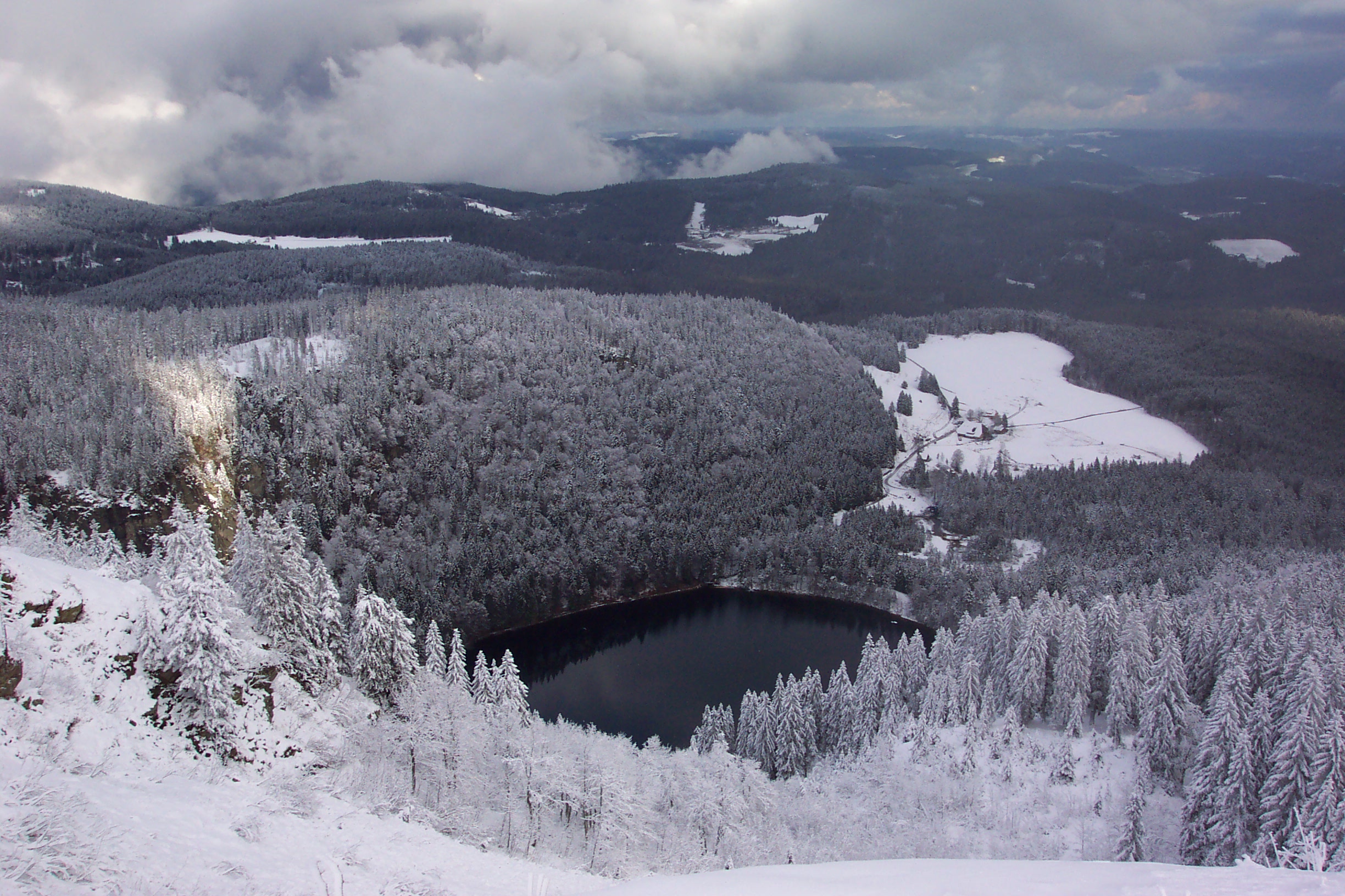
Looking down from Seebuck to Feldsee in winter. Photograph by Florian Jesse · public domain (CC0).
Todtnauberg
Longer laps on the sunny side of Feldberg · 1,000–1,400 m
The Stübenwasen lift is the place to start for the intermediate FIS run. On a blue-sky day the south-facing bowl is the attraction in its own right. For evening skiing, check the separate floodlight listing for Kapellenlift. The lifts have different access roads.
Rental. Mountainsportpark rents alpine equipment at the foot of the Am Buck lift. Collect it there first if you intend to ski from Stübenwasen. Rental details.
Parking. Use P6 on Martin-Heidegger-Weg for the Stübenwasen lift. For an evening at Kapellenlift, use Rüttestraße 14 instead. Arrival and parking.
Horn panorama camera Mountain forecast Live weather map Check lift operation
Muggenbrunn
Gentle at Wasen, steeper at Franzosenberg · 980–1,243 m
Choose your first lift here according to the skier. The Wasenlift and its conveyor serve practice terrain. Stronger skiers can head for the Franzosenberg FIS slope. Check which lifts connect the sectors that day before agreeing to meet on the other side.
Rental. The Wasenlift ski rental is at the beginner area. The resort also lists a separate shop in Todtnau, so double-check the pickup in your booking. Rental details.
Parking. Follow signs for Wasenlift by the campground on Oberhäuserstraße. The lots at the lower station are convenient for fitting equipment and starting on the easy slope. Arrival and parking.
Wasen & conveyor cameras Mountain forecast Live weather map Check lift operation
Notschrei
Short alpine laps beside a Nordic trail network · 1,108–1,194 m
This pass makes sense when half the group wants downhill runs and half wants cross-country trails. Two drag lifts serve easy to intermediate pistes. For a short visit, agree which side of the pass to meet on before everyone heads out.
Rental. Ski Hirt lists basic alpine sets at the Nordic Center, Notschrei-Passhöhe 6. Its last published rental notice marked the previous season closed. Confirm reopening and sizes before relying on this counter. Rental details.
Parking. The tourism board lists free spaces at the ski lifts on the pass. Allow a little extra time if you need to visit the Nordic Center before heading to the alpine lifts. Arrival and parking.
Pass lift camera Mountain forecast Live weather map Check lift operation
Windeck · Hinterzarten
A half-day near Titisee for confident tow-lift riders · 971–1,190 m
Three drag lifts give you a compact circuit above Hinterzarten. This is a good step up from a single practice slope if everyone can already ride a tow. The two- and four-hour ticket options suit a morning on skis followed by lunch in the village.
Rental. Sport Maurer rents skis and snowboards in Hinterzarten village. Stop there on the way to the hill. Rental details.
Parking. Navigate to Skizentrum Windeck. The operator lists free parking at the ski area. The village rental and the lift car park are separate stops. Arrival and parking.
Windeckkopf lift camera Mountain forecast Live weather map Check lift operation

Hofeck · Bernau
Slalom terrain in the Bernauer Hochtal · 962–1,143 m
In the Hof district, a drag lift takes you up to terrain used for slalom and giant slalom. It’s a good hill for working on turns on the same run. Bernau also has the separate Spitzenberg/Köpfle area in Innerlehen. Tickets bought for Hofeck are valid at Hofeck only.
Rental. Sport Thoma rents ski equipment at Rathausstraße 6 in Bernau. Pick it up before driving to the Hofeck lift. Rental details.
Parking. Use Wanderparkplatz Skilift Hofeck in Bernau-Hof, by the lower station on Hofeckweg. The regional tourism board lists the lot as free. Arrival and parking.
Camera facing Hofeck Mountain forecast Live weather map Check lift operation
Kandel · Waldkirch
Blue and black terrain above the Elz valley · 1,055–1,210 m
Two skiers can have distinctly different days on this mountain. Kaibenloch is the blue run, while Schwarzmoos is graded black. Check the lift names in the operating report before making the winding drive up from Waldkirch. The launch-site cameras are especially useful for spotting low cloud on the ridge.
Rental. The upper Kaibenloch lift hut has a small rental stock of carving skis, boots and poles. Snowboarders need to bring or hire their board elsewhere. Rental details.
Parking. Aim for the Kandel summit car park on the L186. Capacity is limited on busy snow days. Read the regional access notice before driving up. Arrival and parking.
Ridge cameras · west & south Mountain forecast Live weather map Check lift operation

Mehliskopf · Bühl/Sand
The widest choice of terrain in this High Road trio · 825–1,008 m
Coming from Baden-Baden or Bühl, Mehliskopf gives a mixed group a reason to stop before driving farther along the High Road. The piste plan distinguishes easy, intermediate and difficult slopes. Choose the Hang camera to see the skiing area. The bob-run camera shows a different part of the site.
Rental. The Schneesport-Schule and rental share a location at the lower lift station, on the right-hand edge of the slope by the trees. Rental details.
Parking. Navigate to Am Stadtwald 4, Bühl/Sand. The paid lot records your number plate. Use the plate number at the pay station or in the online payment system. Arrival and parking.
Slope camera · select Hang Mountain forecast Live weather map Check lift operation
Seibelseckle · Seebach
One floodlit slope and a rental at its foot · 961–1,056 m
A 500-metre piste beside the B500 makes this an easy place to fit in a few runs on the way home. Floodlights extend the day when the lift is operating. Cross-country trails start here as well, and the same rental carries both kinds of equipment.
Rental. Sport Kern fits downhill skis, snowboards and cross-country equipment at the lift. Use the Seibelseckle branch for Nordic gear. Rental details.
Parking. Use Parkplatz Seibelseckle on the B500, Schwarzwaldhochstraße 8, Seebach. The slope, rental and hut share this starting point. Arrival and parking.
Seibelseckle slope camera Mountain forecast Live weather map Check lift operation
Ruhestein · Baiersbronn
Main piste and a forest descent at the national park · 915–1,014 m
Two drag lifts flank the main slope, with a forest descent for a change of scenery. Ruhestein works well for a short session because the operator offers timed tickets. After dark, check that evening skiing is running before making the trip along the High Road.
Rental. Sport Kern rents alpine equipment and snowboards directly at the Ruhestein ski lift. The operator also links to its courses. Rental details.
Parking. Follow the B500 to the signed Ruhestein visitor car parks. They also serve the national park centre. Allow extra time on clear weekends, or use the bus connections on the park’s arrival page. Arrival and parking.
Ruhestein lift camera Mountain forecast Live weather map Check lift operation
Three decisions before you set off
A full day or two hours? For a full day with scope to change runs, start with Feldberg or Todtnauberg. For a morning, Hinterzarten and Ruhestein sell timed passes. For an evening, check the floodlight notice at Seibelseckle, Ruhestein or Todtnauberg’s Kapellenlift. Ruhestein ticket options.
Collect gear at the slope or in town? In Hinterzarten and Bernau, make the village shop your first stop. At Wasenlift and Seibelseckle, park at the slope and walk to the rental. If you’re booking a lesson, match the meeting point on the confirmation to the lift entrance. Feldberg in particular has several starting points.
What is open today? Use the mountain forecast to decide what to wear, and the camera to judge visibility at the slope. For open runs, lift times and evening sessions, use the operator’s dated notice. To compare more than one hill, check the Hochschwarzwald snow report or the Achertal winter sports report.
Taking a child skiing for the first time? Our guide to skiing in the Black Forest with kids compares nursery slopes, ski schools and meeting points for a first lesson.