
Where to Go Sledding with Little Kids in the Black Forest
Compare 10 places to go sledding with kids in the Black Forest, including Kandel. Find gentle hills, sled rentals and a map for every location.
Find your hill ↓
On the first run, everybody wants a turn. By the fourth, somebody has to haul the sled back up. That’s the detail we’d plan a Black Forest snow day around, especially with two children who have very different ideas about how many runs are enough.
If it’s a first ride, we’d start with An der Wanne in Löffingen or the meadow by Dobel’s water tower. For a child who wants another turn before you’ve caught your breath, head for a conveyor at Notschrei or Altglashütten. If you’re staying near Triberg, Schönwald and Schonach give you two longer runs without a trip down to Feldberg.
The overview map shows all ten hills. If the walk from the car is what matters most, start with Schonach or Altglashütten. Each local map marks the sledding area. Under “Parking” you’ll find the lot to aim for, the approach on foot and any busy-day warnings. Before you pack the sleds, check the time on the webcam image. The local snow report will tell you whether the run is open.
An der Wanne in Löffingen
Southern Black Forest · 100 m run · 5 m descent
A gentle first slide. Five meters of drop across the whole hill is the reason to come here. A child trying a sled for the first time can start partway up, with an adult standing at the bottom. The meadow is ungroomed, so a snowfall that barely covers the grass is a good reason to choose another day.
Parking. Plan for a walk from town. The approach to An der Wanne starts at the end of Hebelstraße. The town lists no dedicated lot there. One public option is Baderparkplatz on Bittengasse (17 spaces). Check the posted time limit, then walk to the end of Hebelstraße with your sled.
Sled rentals. Bring your own to An der Wanne. The town’s older winter guide lists a loan service in town, but the regional tourism office now directs equipment enquiries to Titisee. We could not confirm a pickup point at the hill. Current visitor information
Webcam. Look for the Alenberg view on the town’s webcam page. It shows the weather over Löffingen. Snow cover can be different on the An der Wanne meadow. Löffingen town webcams
Official hill details · Town’s sledding information · Town parking
Schwarzenbachlift in Altglashütten
Feldberg area · 100 m run · 28 m descent
Repeat rides with a conveyor. This is the same length as Löffingen with more than five times the drop. We’d pick it for a child who already enjoys the slide and loses patience on the climb. A paid conveyor takes care of the return when it’s running. The Vesperstube Geißenhof beside the hill gives the rest of the family somewhere to warm up.
Parking. Easy to find, right by the lift. Enter Schwarzenbachlift, Schwarzenbachweg 17, in your navigation app. Parking is beside the ski slope, handy if you’re carrying a sled and a tired child. If you take the bus, the Sparkasse Altglashütten stop is about 200 m from the sledding area. Lift and parking details
Sled rentals. Yes, in the village. Skiverleih Schubnell rents sleds at Bärentaler Straße 1 in central Altglashütten. Collect yours before heading to the Schwarzenbachlift. Schubnell rental details
Webcam. The camera at the Schwarzenbachlift gives you a look at conditions in Altglashütten. Check the lift report separately if you’re counting on the conveyor. Schwarzenbachlift webcam

Pfisterwald in St. Märgen
Southern Black Forest · 300 m run · 36 m descent
A longer ride for confident children. The word Spielplatz means playground, and it’s a handy landmark. The tourism office grades the sled run itself intermediate. If the children have only tried little garden slopes, we’d start elsewhere. For a family that can already steer and brake, this is a good step up from the short Feldberg runs.
Parking. Easy to find, with a short walk. Head for Parkplatz Sportplatz at Sportplatz 1. There’s a spacious public lot by the sports ground, so you have a clear place to aim for. From there, walk toward the Pfisterwald playground. By bus, Vogelhof is about 300 m from the hill and St. Märgen Post about 400 m.
Sled rentals. Yes, in St. Märgen. Ski und Rodel Ernst Mark rents sleds at Feldbergstraße 19. Pick up there before continuing to the Pfisterwald hill at the sports ground. Ski und Rodel Ernst Mark
Webcam. The panorama from Haus Ruf looks across St. Märgen. It’s handy for spotting fog in the village before you drive up to the Pfisterwald. St. Märgen village panorama
Notschrei Pass near Todtnau
Southern Black Forest · 100 m run · 12 m descent
A gentler conveyor option. Of the two short conveyor hills in this guide, Notschrei has the smaller vertical drop. That makes it a useful middle ground when one child is ready for laps and the other is still warming to the idea. There is a charge for the belt. The Waldhotel is about 100 m away if cold fingers call time early.
Parking. Easy to locate, but spaces can go early. Use Parkplatz Notschrei, Notschrei-Passhöhe 2. Skiers and cross-country skiers use the pass too, so we’d arrive early on a sunny snow day. The Notschrei bus stop is about 50 m from the sledding area. Check that the conveyor is running before you set out. Pass parking
Sled rentals. Yes, at the hill. Notschrei is a Rodel-to-go pickup point. Rentals depend on opening hours and stock, and the program requires a deposit. Rodel-to-go rental details
Webcam. The lift operator’s camera shows the ski area at the pass. It’s a good first look at the snow before you load the sleds. Notschrei lift webcam

Radschert in Todtnauberg
Southern Black Forest · 210 m run · 22 m descent
A longer, easy-rated hill. For children ready to spend a little longer on the sled, Radschert has roughly twice the distance of Altglashütten and a smaller total drop. The tourist office rates it easy. If you have one enthusiastic rider and one who might only try once, agree where you’ll regroup before the first run.
Parking. Easy to find by its lot number. Look for the paid Wanderparkplatz Radschert (P8), Radschertstraße 12. The lot and sledding hill share that address. If you rent a sled at the Bucklift, collect it before driving up to P8. From the Rathaus bus stop, allow for a 1.2 km approach. P8 parking details
Sled rentals. Yes, elsewhere in Todtnauberg. The Mountainsportpark shop at the Bucklift, Allee 8, rents sleds. Pick one up there before driving or walking to Radschertstraße. Bucklift rental shop
Webcam. The panorama at the Horn looks over Todtnauberg. Use it to judge visibility in the village before heading up to the Radschert. Todtnauberg panorama from the Horn
Dobel-Skilift in Schönwald
Near Triberg · About 300 m · Beside the outdoor pool
A long run with rental nearby. The sledding space sits left of the ski piste, beside the Freibad. That gives you an unmistakable landmark when you arrive, especially if you’re looking at two different “Dobel” hills on a map. A 300 m run is a good step up for children who want a longer ride.
Parking. Two easy-to-find options, both a short walk. Try the end of Franz-Schubert-Straße in Schönwald first. If those spaces are taken, head to the Rathaus. The tourist office puts both about 200 m from the hill by the outdoor pool. Choose Schönwald in your navigation app to avoid the separate hill in the town of Dobel.
Sled rentals. Yes, when the ski lift operates. Sport-Weiß’s test center rents sleds beside the Dobel-Skilift in the outdoor pool grounds. If the lift is closed, bring your own. Schönwald rental and hill details
Webcam. The Dobel ski lift has its own camera. This is the view to check for snow at the lift in Schönwald. Schönwald’s Dobel lift webcam

Winterberg in Schonach
Near Triberg · 200 m run · Separate sledding slope
A village outing with a warm-up stop. Schonach has a dedicated sledding hill close to the village center. It’s a good choice if one adult wants to take a few laps with the children while the other sits down for something warm at the Josenalm.
Parking. One of the easiest with small children. From central Schonach, take Sommerbergstraße toward Obertalstraße 15. The large lot is on your left, right beside the sledding hill. This is a good pick if you want to keep the walk from the car as short as possible. Check the local snow report for closures before leaving.
Sled rentals. Yes, at Winterberg. The local tourism office lists Sport Hör’s Skibox as the on-site rental point. Check that the ski box is open on your chosen day. Schonach rental and hill details
Webcam. The town camera shows central Schonach. Check it for local weather, then use the local snow report for the Winterberg run. Schonach town center webcam
The water tower hill in Dobel
Northern Black Forest · About 250 m · Gentle meadow
A first outing in the northern Black Forest. If you’re on the Bad Herrenalb side of the forest, this is the gentle hill we’d put first. The sled run occupies the meadow between the Kurhaus and the water tower, to the right of the small ski lift. There’s room to try a short section before committing to the full length.
Parking. Two marked lots, then a walk to the meadow. Start with Parkplatz am Kurhaus. The slope is on the meadow between the Kurhaus and the water tower. The Sportplatz/Friedhof lot is a second option near the tower. Both charge for daytime parking. Höhenstraße 40 is the sledding address. From the Dobel Ortsmitte bus stop, walk toward the tower. Town parking map and fees
Sled rentals. Bring your own to the water tower. The municipality describes the run and lists other winter equipment for hire, but we could not verify a sled rental at this hill. Dobel municipal winter guide
Webcam. The live camera looks out from the water tower over Dobel. If you’re coming for the meadow below the tower, the stream is a handy check for fog. Live view from the Dobel water tower
Ruhestein by the National Park Centre
Northern Black Forest · Mountain pass · Intermediate to difficult
An option for experienced riders. This is the one we’d save for a family with confident riders. Regional tourism describes it as intermediate to difficult. Its appeal is the location beside the National Park Centre, so a mixed-age family can split up or switch activities. For a toddler’s first descent in the northern forest, our pick is Dobel.
Parking. Clearly marked, with live availability to check. Aim for Nationalparkzentrum (P1) or Ruhestein (P2) on the pass. Both are paid lots. The operator’s vParken app shows how many spaces are free, worth checking before the drive on a snowy weekend. Bring a payment card for the machine at P2. P1 also accepts cash. The National Park Centre is served by bus. National Park parking and bus information
Sled rentals. Yes, at the lift. Sport Kern lists sleds at its Ruhestein station. It generally opens when the lift runs. Check the station before making the trip for a rental. Sport Kern rental stations
Webcam. The lift operator’s camera shows the ski area at Ruhestein. Check the picture for snow and visibility at the pass before the drive. Ruhestein lift webcam
Official hill details · National Park region sledding report and runs
Kandel above Waldkirch
Above Waldkirch · Dedicated sledding hill · Sled tow
A lift for the ride back up. There’s a designated sledding hill beside the Kaibenlochlift. The separate Schlittenlift tows you uphill sitting on your sled. The operator allows one person per sled on the tow. If a little one would need to ride up on your lap, choose a different lift arrangement for the day.
Parking. Easy to find, but the summit lot can fill. From Waldkirch, take the L186 to the public summit lot. The Kandel bus stop is at the lot, and the sledding area is beside the Kaibenlochlift. The city warns that the summit lots can fill and the access roads can close at short notice. Check local traffic notices and the sled tow’s operating status before driving up. Waldkirch’s winter access notice
Sled rentals. Yes, in limited numbers at the sled-lift ticket desk during lift operation. The operator lists a rental fee plus a deposit. Families who need several sleds should check availability before going up. Kandellifte rental and lift rules
Webcam. The local flying club has west and south views from its launch sites on the Kandel. They’re useful for spotting low cloud on the mountain. For sled-lift hours, check with the lift operator. Kandel west and south webcams
Compare the ten sledding hills
Run length tells you how long the ride lasts. Total drop gives you a sense of how much climbing you have to do between runs. Löffingen and Altglashütten both measure about 100 m, yet their drops are 5 m and 28 m. The chart also shows where to pick up a sled. A village pickup means a separate stop before the hill.
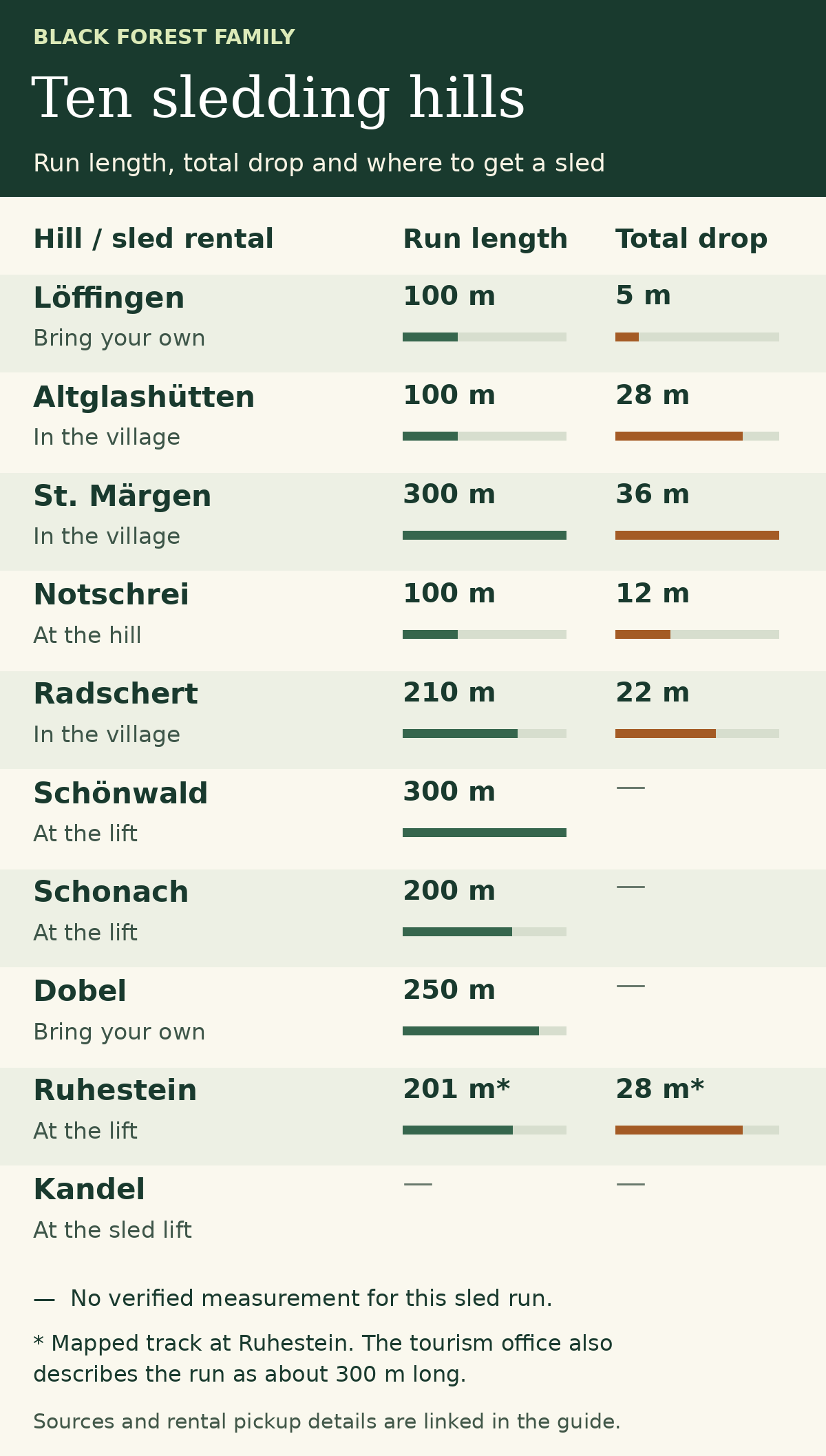
Distances are approximate. A dash means the official sources do not give a verified measurement for the sled run. For Ruhestein, Baiersbronn’s mapped route is 201 m with 28 m of descent. The same listing describes the run as about 300 m long. “Bring your own” means we could not confirm a dependable local pickup. Graphic by Black Forest Family.
What to check before leaving home
Snow on your hill. Open the Hochschwarzwald snow report for the southern and central locations or the National Park region’s winter information for Ruhestein. For Dobel, use the municipal winter guide. Look at the report date, snow coverage and whether that particular hill is open. A photo from Feldberg tells you very little about the meadow in Löffingen.
The ride back up. If a conveyor or rental sled makes the outing possible for your family, confirm it with the operator that morning. Pack helmets, boots with good grip and an extra pair of mittens. At the bottom, check that the runout is clear and walk back up at the side. Sledding advice from the Swiss Council for Accident Prevention
Making a weekend of it? Read our Feldberg guide for nearby stops, or keep these indoor outings with kids handy if the snow turns to rain.